DiveTopo

Dive site maps of Réunion Island

Pont Rouge

Saint-Leu, Réunion Island21° 09′ 47.6″ S · 55° 17′ 16.3″ E

View site on Google Maps
View type
Map background
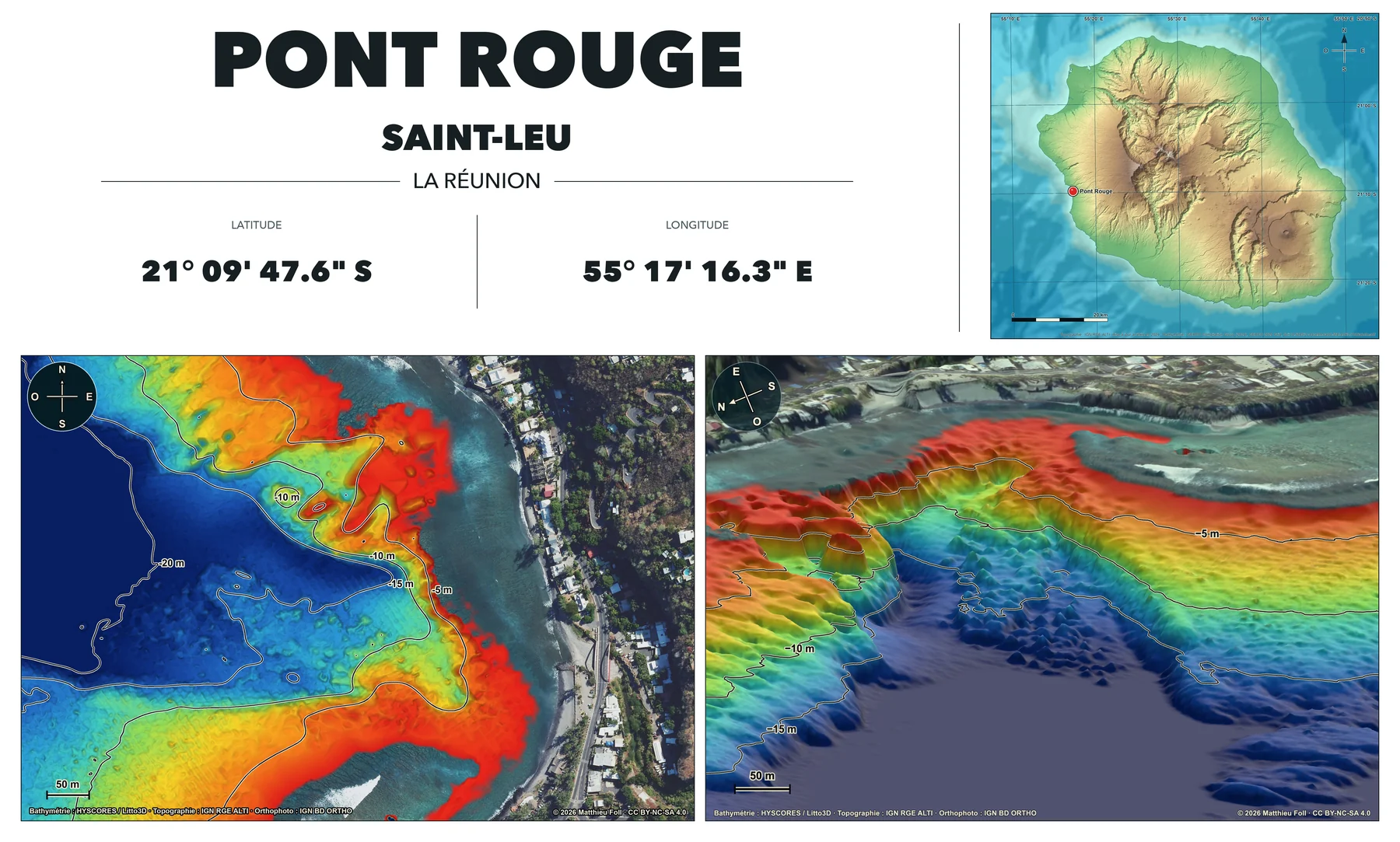
Preview of the printable map sheet for Pont Rouge, with an aerial-imagery basemap.
Printable high-resolution map sheetPont Rouge · Aerial imagery
Download the high-resolution sheet

Data, method and licences

This project is made possible by freely available bathymetric, topographic and aerial data provided by public and scientific organisations.

02

Topography

The RGE ALTI digital terrain model used for the land surface.

03

Aerial imagery

Georeferenced IGN BD ORTHO aerial imagery used for the high-resolution background.

04

Regional terrain

The GEBCO 2024 bathymetric grid used for the west-coast site-selection map.

Cartographic processing

Production method

The code and website interfaces were generated entirely with AI under human direction, then visually reviewed and validated against the source data.

  • Sources and cache validationHYSCORES digital terrain models for the seabed, RGE ALTI for land and 20 cm IGN orthophotography are cropped to each site extent and aligned on a common WGS 84 / UTM zone 40S grid (EPSG:32740). Before rendering, the pipeline validates their source, extent, resolution, bands, content and SHA-256 fingerprint.
  • Land-sea fusionMarine elevations are converted to positive depths, then bathymetry and topography are merged around a shoreline interpolated at 0 m. Gaps remain empty by default; a documented deep-water boundary may be completed locally with a uniform plateau at the maximum depth, without inventing intermediate relief. In the aerial-imagery version, the image is aligned to the bathymetric grid, remains opaque to −1.5 m and then fades progressively to −2 m.
  • Maps and perspectivesThe maps use isobaths at 5 m intervals, down to −20, −30 or −40 m depending on the site. In the interactive 3D view, they are extracted from the raw terrain, smoothed as vectors, then reprojected to their exact depth. Their black line with a white outline is occluded by the terrain, and selected lines carry direct depth labels without a coloured legend. The detailed 2D map remains north-up; the 3D view uses a larger extent, a site-specific azimuth and framing, an offshore camera and ×4 vertical exaggeration.
  • Terrain and output formats3D terrain lighting is calculated from metric normals, using a cool hemisphere light, a warm directional light and linear exposure of 1.55. The fused surface is also exported for the Web with its extent and initial framing as a 16-bit height field, compact masks and two textures; the high-resolution sheets then combine the island locator, 2D map and 3D perspective.

Credits and licence

Maps and visualisations © 2026 Matthieu Foll.

CC BY-NC-SA 4.0

Safety

These maps are not intended for navigation and do not replace local information, sea conditions, guidance from authorities or professional advice.

Contact

Have a question, feedback, or a dive site you would like to see mapped?
Email me at contact@divetopo.com.
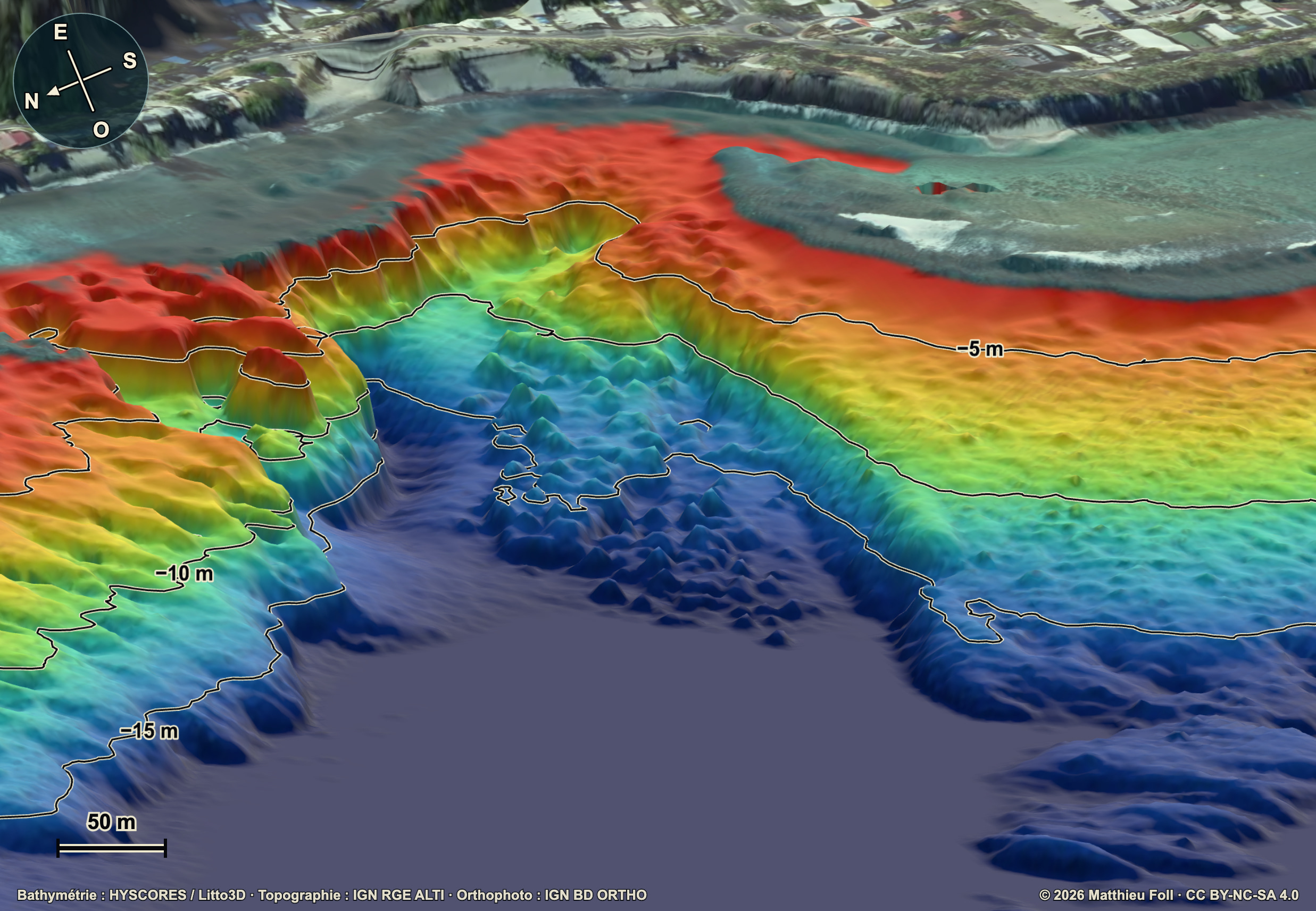
Oblique 3D perspective of Pont Rouge, with an aerial-imagery basemap and approximately fourfold vertical exaggeration.
Land and underwater terrain around Réunion Island. A rectangle marks the west-coast area covered by the site-selection map.